Fort Totten, Queens


Fort Totten Park is a former United States Army installation in Bayside, Queens on the north shore of Long Island. Decommissioned as a military base in the 1970s, Fort Totten is located at the head of Little Neck Bay where the East River widens to become the Long Island Sound. Although the United States Army Reserve maintains a presence since 1974, the property is currently owned by the City of New York.
Fort Totten Flag Bearers
New York Public Library

Construction began in 1862 after the United States government purchased the land from the Willet family.  The former federal military base was composed of 93 acres.  Plans for the Civil War-era project were initially prepared by Captain Robert E. Lee in 1857.  Construction was undertaken five years later to protect the eastern approach of New York Harbor from the Confederate States, along with Fort Schuyler across the East River in the Bronx.

The fort was named for General Joseph Gilbert Totten (1788-1864), Chief Engineer of the United States Army, regent of the Smithsonian Institution, and co-founder of the National Academy of Sciences.

The Willet's farmhouse, built in 1829, is located within the complex but predates the military installation.  Also notable within the site is the historic fort itself, a 19th century artillery battery.
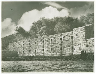
Fort Totten
New York Public Library
The fort's defensive facilities quickly became obsolete and was repurposed in 1864 for casualty care.  The Fort Totten Army Hospital has been vacant since 1965 and was first known as the Post Hospital and later renamed for Dr. Walter Reed.

In 1987 the United States Department of Defense transferred 10 acres of land at Fort Totten to the New York City Department of Parks and Recreation as a gift for Bayside area parkland.
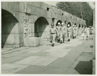
Men Marching Fort Totten
New York Public Library
In 2001, the majority of the Fort came under the jurisdiction of the New York City Department of Parks and Recreation - nearly 61 acres.  The remainder is operated by the New York Fire Department and New York Police Department as a training center.  St. John's University and the Bayside Historical Society also use facilities on-site such as Fort Totten's former Officer's Club.

Popular posts from this blog

Franklin D. Roosevelt Drive, Manhattan

East River Drive at 81st Street June 8, 1942 Museum City of New York Franklin D. Roosevelt Drive, formerly the East River Drive, is 9.5 miles long. The FDR Drive extends from the Battery to the Triborough Bridge. The Drive is not designed to current interstate standards, therefore the FDR is closed to commercial traffic. However buses can use the highways in certain locations. Due to its antiquated design, the speed limit maximum is 40 miles per hour. In the 1920s, calls first began for a waterfront highway began - initially being called the "Chyrstie-Forsyth Parkway." The FDR Drive is an amalgamation of sections that were constructed in different styles. Construction of the East River Drive began in 1934. The parkway section from East 92nd street to East 125th required ingenious methods of construction in a narrow right-of-way. A six-lane parkway was conceived by Robert Moses in the 100 foot right-of-way. This section was completed and opened in 1936. East ...

Annadale, Staten Island

Annadale Named in 1860 for Anna Seguine, a descendant French Huguenot and among the south shore's earliest settlers. In 1929, Spanish immigrants purchased land totaling 17 acres along Annadale's shoreline that become known as Spanish camp or Spanish Colony. Dorothy Day, the social activist and leader of the Catholic Worker Movement, purchased one bungalow in 1972. By the 1990s however, developers had aggressively purchased the neighborhood's property. The sale forced 45 families to move and subsequently the demolishing of the buildings for upscale homes. The new development, named Central Park East preserves solely the street grid. A city park in the heart of Annadale was converted into a wildlife preserve. Blue Heron Park Preserve covers 222 acres of woodlands, ponds, swamps and small streams which empty into Raritan Bay. The intersection of Annadale Road and Jefferson Blvd. form a triangle of green space.  This fell under the jurisdiction of the Staten Is...